Strategy 6 Seek design exceptions and variance to established standards when standards established by other units of government conflict with the City’s Complete Streets Policy.
The actions within this strategy are divided into two categories:
Action we will DOActions we will SUPPORTAction we will do are followed by “DO” and are colored in dark gray, and actions we will support are followed by “SUPPORT” and are colored in light gray.
Learn more about how we get there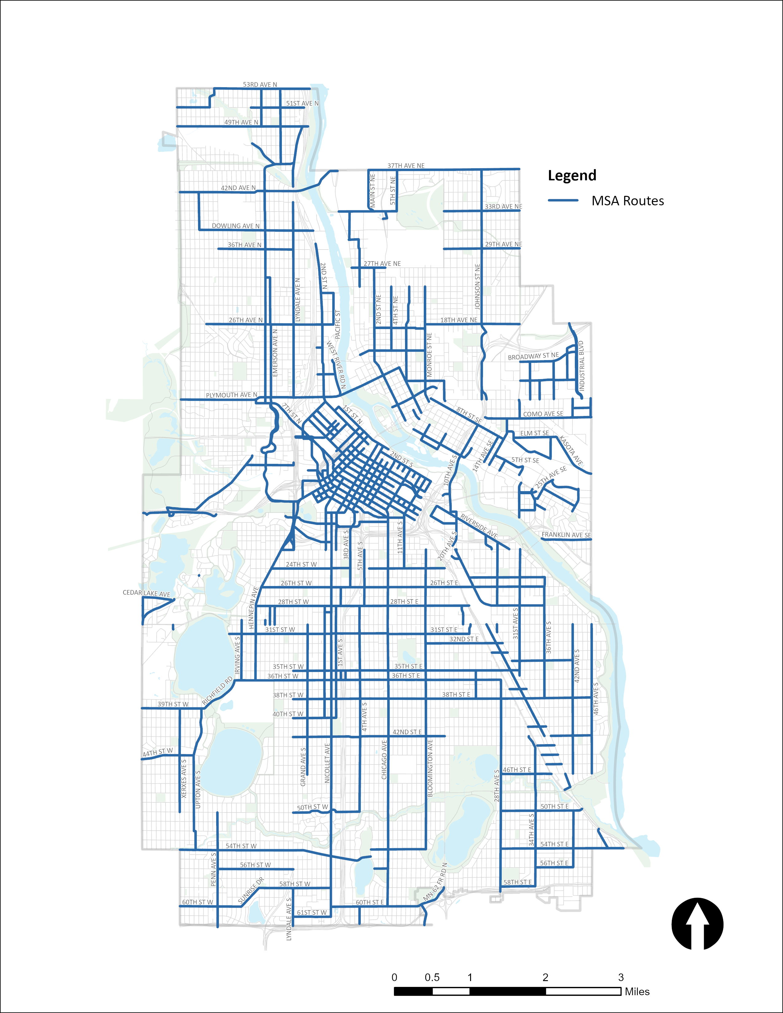
Actions to seek design exceptions and variances when standards established by other units of government conflict with the City’s Complete Streets Policy.
Design 6.1
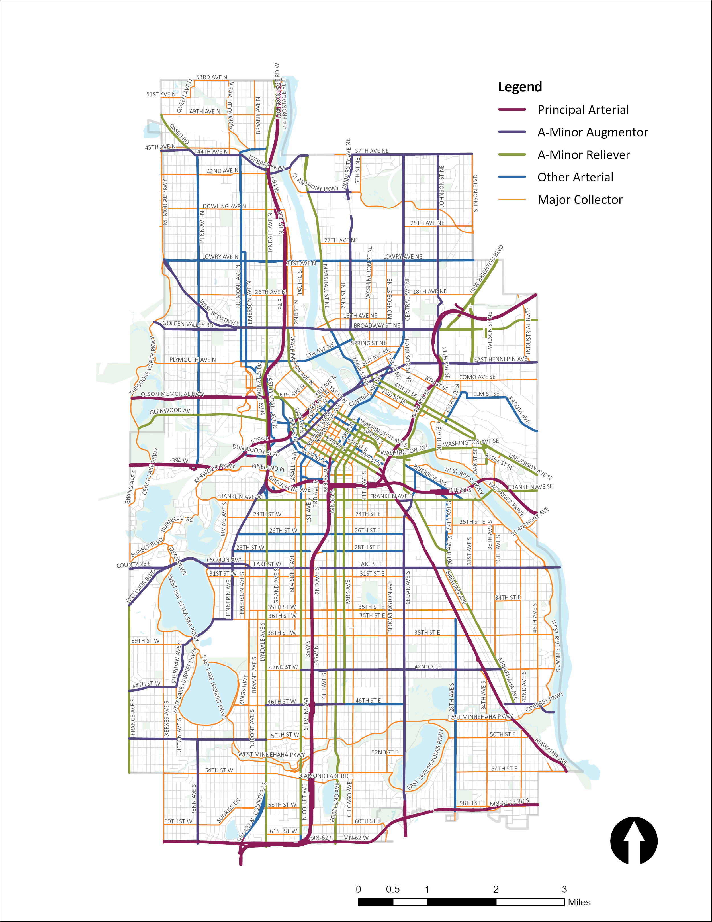
Work with the Minnesota Department of Transportation to request changes to the Twin Cities Regional Functional Classification System to better align with updated street typologies in the Street Design Guide. Initial changes include:
- Add 3rd St N/S from 2nd Ave N to Portland Ave as an A-Minor Arterial on the regional functional classification system.
- Add 6th St N/S from 2nd Ave N to 13th Ave as an A-Minor Arterial on the regional functional classification system.
- Add 11th St N/S and 12th St N/S from I-35W exit to Hawthorne Ave as A-Minor Arterials on the regional functional classification system.
- Add Hawthorne Ave from I-394 entrance/exit to 10th St N as an A-Minor Arterial on the regional functional classification system.
- Add 4th Ave S from Washington Ave S to 7th St S as an A-Minor Arterial on the regional functional classification system.
- Add 5th Ave S from Washington Ave S to 7th St S as an A-Minor Arterial on the regional functional classification system.
- Change 26th St E/W from Hennepin Ave S to Cedar Ave from Other Minor Arterial to Major Collector and extend to Minnehaha.
- Change 28th St E/W from Hennepin Ave S to Cedar Ave from Other Minor Arterial to Major Collector and extend to Hiawatha.
- Remove Minnehaha Ave from 26th Ave to Cedar Ave as an A-Minor Arterial on the regional functional classification system.
- Remove 42nd St E from Nicollet Ave to Cedar Ave as an A-Minor Arterial on the regional functional classification system and replace with an alternative east-west route with access to I-35W, for example: 35th St and 36th St or 31st St between Lyndale Ave and Park Ave
- Add Diamond Lake Rd from Lyndale Ave S to Portland Ave S as an A-Minor Arterial on the regional functional classification system.
- Remove as an A-Minor Arterial on the regional functional classification system Hennepin Ave S from Lake St to 36th St, 26th St W from Hennepin to Richfield Rd, Richfield Rd/39th St from 36th St to Sheridan Ave S, Sheridan Ave S/Upton Ave S from 39th St to 44th St, and 44th St W from Upton Ave to France Ave.
- Remove St Anthony Pkwy NE from Marshall St NE to University Ave NE as an A-Minor Arterial on the regional functional classification system.
- Adjust other streets as appropriate.
Supported goals:
Active Partnerships
Related actions:
Difficulty:
Low
Timeframe:
2020-2023 (Years 0-3)
Status:
Complete
Significant milestone(s):
In 2021, the Minnesota Department of Transportation updated the Regional Functional Classification System as requested by Minneapolis Public Works. Nearly all of the requested changes were completed.
Design 6.2
Evaluate potential changes the City may request to the Municipal State Aid Routes to better align with the updated street typologies.
Supported goals:
Active Partnerships
Related actions:
Difficulty:
Low
Timeframe:
2020-2023 (Years 0-3)
Status:
Successfully completed to date and on-going
Significant milestone(s):
In 2021, 2022, and 2025 the City has made several revisions to the Municipal State Aid (MSA) system. Revisions are made to align with street typologies in the Street Design Guide and TAP multimodal networks such as the All Ages and Abilities bikeway network. Most notably, the City was successful in adding 5th St and 6th St downtown to the MSA system network and removing other streets that do not align well with the MSA system guidance. MSA system revisions will continue to be evaluated, as necessary.
Design 6.3
Evaluate potential changes to the Municipal State Aid Rules the City may advocate for to provide flexibility needed for the City to use the Street Design Guide with few or no variances.
Supported goals:
Active Partnerships
Related actions:
Difficulty:
Low
Timeframe:
2024-2027 (Years 4-7)
Status:
In Progress
Significant milestone(s):
Public Works has advocated at the state level to update MSA guidance and rules to allow for 10-foot travel lanes, vertical traffic calming, and to design to local speed limits as a standard and not require a variance.
Design 6.4
Evaluate the need for variances, design exceptions and pilots to support the use of the Street Design Guide during street reconstruction projects.
Supported goals:
Mobility Active Partnerships
Related actions:
Difficulty:
Low
Timeframe:
2020-2023 (Years 0-3)
Status:
Successfully completed to date and on-going
Significant milestone(s):
Public Works explores and pursues variances, design exceptions and pilots on a project by project basis. Recent examples include the 9th/10th Street Corridor Improvement project, Cedar Lake bridge and Dinkytown Pedestrian Improvement project.
See also actions:
- Freight 2.3
Design vehicles on State Aid system